University of Miami

Michael S. Fischer

Assistant Professor of Atmospheric Sciences

Department of Atmospheric Sciences Assistant Professor · Rosenstiel School
Frost Institute for Data Science and Computing (IDSC) Core Faculty

My research focuses on tropical cyclone structure and intensity change, particularly the inner-core processes that govern rapid intensification. The work draws on airborne Doppler radar, geostationary satellite observations, and machine learning, with an aim of developing methods that transfer to an operational setting.

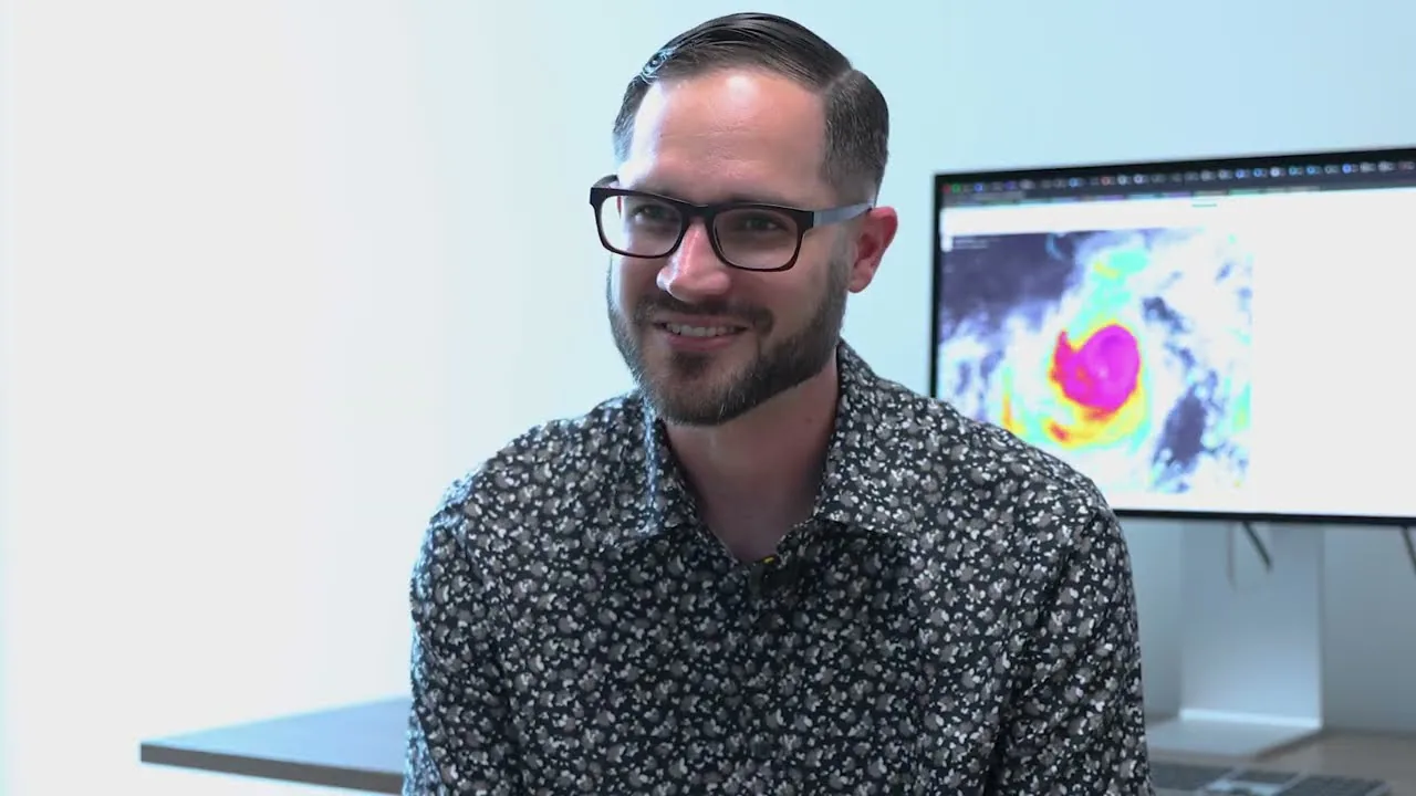
Portrait of Michael S. Fischer
Doppler radar analyses
1,640 swaths
Storms in the archive
13,559 global
Radar record
1997–2025
Public resources
3 datasets & tools

About

Inner-core structure and intensity change

My appointment at the University of Miami spans two units: I am an Assistant Professor in the Department of Atmospheric Sciences at the Rosenstiel School, and core faculty at the Frost Institute for Data Science and Computing. The joint appointment reflects the structure of the work, which draws on tropical meteorology and on statistical and machine-learning methodology in roughly equal measure. Much of it develops from collaboration with NOAA’s Hurricane Research Division and the airborne radar observations that underpin it.

Operational track forecasts have improved substantially over recent decades; forecasts of intensity have improved far less. My work addresses that disparity. Using observations, numerical simulations, and machine learning, I examine how convection, vortex tilt, and the surrounding environment interact to determine whether a storm undergoes rapid intensification.

A second theme concerns observational coverage. Aircraft reconnaissance samples only a small fraction of global tropical cyclones, almost entirely in the North Atlantic. Recent work asks how much of the storm state can be recovered from satellite-only inputs — models trained on aircraft observations but requiring none at inference — in order to extend structural analysis to basins where reconnaissance is unavailable.

Research

Current research questions

The questions are interdependent: results on vortex tilt inform predictor selection in the statistical models, which in turn supply the data products described below.

What is the predictability limit for rapid intensification?

Track forecast skill has improved substantially; intensity forecast skill has not. How much of the residual error is intrinsic — set by chaotic, convective-scale variability in the inner core — and how much remains recoverable through improved observations and model formulation?

By what pathways does a tilted vortex align?

A vertically misaligned vortex can align by more than one route, and the pathway taken appears to condition the subsequent intensity evolution. Identifying these pathways in observations, and determining what selects among them, is the subject of several recent papers.

Over what scales is S2S tropical cyclone activity predictable?

Between the synoptic forecast range and the seasonal outlook lies the subseasonal range, where modes such as the MJO and BSISO modulate the timing and location of genesis. The spatial and temporal limits of that predictability remain to be established.

Can machine learning estimate 3-D storm structure in real time?

Aircraft sample only a small fraction of storms. TC-SWARM evaluates whether continuously available satellite and reanalysis fields can reconstruct the three-dimensional wind field at latencies compatible with operational use rather than retrospective analysis.

Projects & platforms

Open datasets and analysis tools

Each originated as a research requirement and is now maintained as a public resource: an interactive platform, a modeling framework, and an open observational dataset.

Live platform tcatlas.org

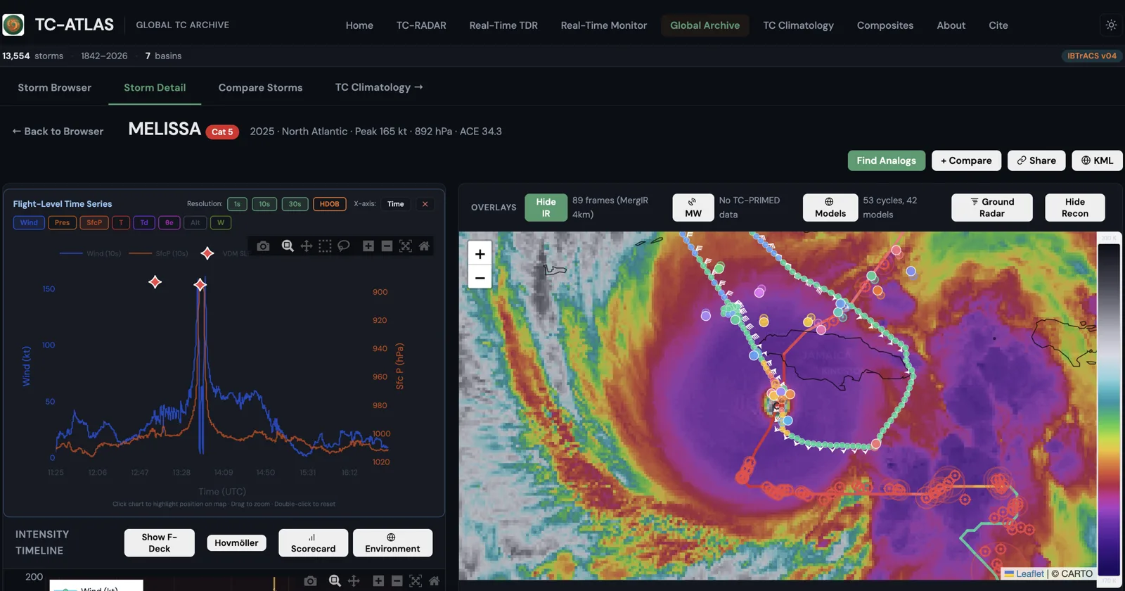
TC-ATLAS

Interactive access to real-time and historical tropical cyclone observations

TC-ATLAS integrates satellite, radar, aircraft, and environmental observations for tropical cyclones within a single interactive platform. The real-time component tracks active storms globally using infrared imagery, passive microwave overlays, scatterometer surface winds, aircraft reconnaissance, and numerical model guidance. A global archive spans the historical best-track record, and the TC-RADAR airborne Doppler database is accessible case by case.

The platform is intended to serve operational situational awareness, research access to the underlying observations, and instructional use, exposing the same data at each level.

Manuscript in preparation Machine learning

TC-SWARM & GHOST

Hurricane structure from satellite imagery alone

Aircraft reconnaissance provides the most reliable constraint on inner-core structure, but samples only a minority of storms and, for those, only intermittently. TC-SWARM — the Tropical Cyclone Satellite Wind Analysis and Reconstruction Model — is a hierarchical machine-learning framework that learns the mapping from continuously available geostationary infrared imagery and reanalysis environmental fields to the three-dimensional wind fields measured by airborne Doppler radar.

Its first stage is GHOST, the Geostationary-based Hurricane Objective Strength Technique, which estimates a storm’s scalar state — maximum sustained wind, minimum pressure, and radius of maximum wind — from satellite and environmental data. Both are trained on reconnaissance observations but require none at inference: reconnaissance-informed training, reconnaissance-independent application. The objective is to extend structural analysis to storms that reconnaissance does not sample.

The GHOST manuscript is in preparation for Weather and Forecasting, with the TC-SWARM wind-field reconstruction to follow.

Training analyses
~1,500
Model stages
3
Aircraft inputs at inference
0
Open dataset Version 4.0 Hosted in TC-ATLAS

TC-RADAR

Storm-centered airborne Doppler radar analyses, 1997–2025

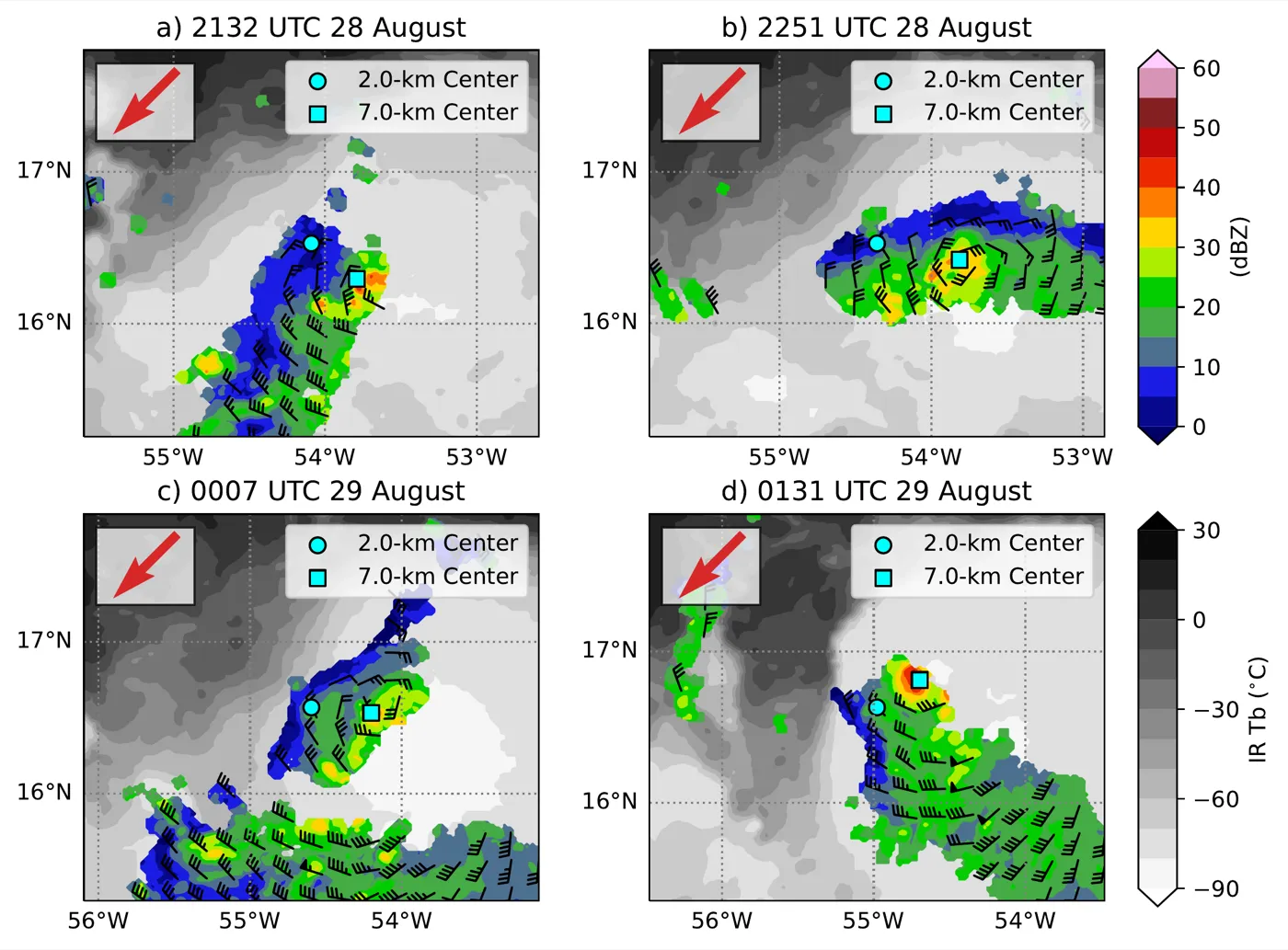
The Tropical Cyclone Radar Archive of Doppler Analyses with Recentering compiles tail Doppler radar observations from NOAA P-3 reconnaissance flights into a uniform, storm-centered database. Version 4.0 extends the record through the 2025 season: 1,640 individual swath analyses and 474 merged analyses spanning the North Atlantic and eastern and central North Pacific.

Every case carries three-dimensional winds, reflectivity, and derived kinematic fields on a common grid, with multiple center-fix conventions including tilt-relative recentering. The dataset underlies much of the observational work described above and provides the training labels for TC-SWARM.

Four sequential tail Doppler radar swath analyses of a tropical cyclone, showing radar reflectivity and wind barbs over infrared brightness temperature with 2-km and 7-km circulation centers marked.
Swath analyses
1,640
Merged analyses
474
Coverage
1997–2025

Publications

Selected work

Selected from 20 peer-reviewed articles, with manuscripts submitted and in preparation, and invited chapters. The complete list is on Google Scholar and in the CV.

Refereed journal articles

2026
To align or not to align? That is the question
Fischer, M. S., G. R. Alvey III, D. Jariwala, and P. D. Reasor
Journal of Geophysical Research: Atmospheres, 131, e2025JD045986
https://doi.org/10.1029/2025JD045986 Open access
2025
Reconsideration of the mass and condensate sources for the tropical cyclone outflow
Nolan, D. S., M. S. Fischer, and M. E. O’Neill
Bulletin of the American Meteorological Society, 106, E1342–E1359
https://doi.org/10.1175/BAMS-D-24-0284.1
2025
Are rapidly intensifying tropical cyclones associated with unique vortex and convective characteristics?
Fischer, M. S., P. D. Reasor, J. P. Dunion, and R. F. Rogers
Monthly Weather Review, 153, 183–203
https://doi.org/10.1175/MWR-D-24-0118.1
2024
A review of the interactions between tropical cyclones and environmental vertical wind shear
Rios-Berrios, R., P. M. Finocchio, J. J. Alland, X. Chen, M. S. Fischer, S. Stevenson, and D. Tao
Journal of the Atmospheric Sciences, 81, 713–741
https://doi.org/10.1175/JAS-D-23-0022.1
2024
An observational analysis of the relationship between tropical cyclone vortex tilt, precipitation structure, and intensity change
Fischer, M. S., R. F. Rogers, P. D. Reasor, and J. P. Dunion
Monthly Weather Review, 152, 203–225
https://doi.org/10.1175/MWR-D-23-0089.1
2023
On the distribution of convective and stratiform precipitation in tropical cyclones from airborne Doppler radar and its relationship to intensity change and environmental wind shear direction
Wadler, J. B., J. J. Cione, R. F. Rogers, and M. S. Fischer
Monthly Weather Review, 151, 3209–3233
https://doi.org/10.1175/MWR-D-23-0048.1
2023
A tale of two vortex evolutions: Using a high-resolution ensemble to assess the impacts of ventilation on a tropical cyclone rapid intensification event
Fischer, M. S., P. D. Reasor, B. H. Tang, K. L. Corbosiero, R. D. Torn, and X. Chen
Monthly Weather Review, 151, 297–320
https://doi.org/10.1175/MWR-D-22-0037.1
2022
An analysis of tropical cyclone vortex and convective characteristics in relation to storm intensity using a novel airborne Doppler radar database
Fischer, M. S., P. D. Reasor, R. F. Rogers, and J. F. Gamache
Monthly Weather Review, 150, 2255–2278 — TC-RADAR database description
https://doi.org/10.1175/MWR-D-21-0223.1

Submitted and in preparation

2026
Mid-level outflow in tropical cyclones observed by airborne Doppler radar
Fischer, M. S., E. Danto, D. S. Nolan, W. G. Bouza, and E. Siman
Monthly Weather Review — submitted
2026
The path to alignment: Dual-Doppler and SAMURAI observations of Tropical Cyclone Fiona (2022)
Alvey III, G. R., J. Zhang, J. Dunion, B. Dahl, and M. S. Fischer
Monthly Weather Review — in preparation
2026
A geostationary, reconnaissance-independent technique for estimating tropical cyclone intensity and radius of maximum wind (GHOST)
Fischer, M. S., and co-authors
Weather and Forecasting — in preparation
2026
Estimating tropical cyclone vortex tilt from geostationary satellite imagery using a random forest
Fischer, M. S., W. Bouza, D. Jariwala, and M. Reardon
Weather and Forecasting — in preparation

Book & encyclopedia chapters

Media

In the news

Video features, television interviews, and press coverage of recent research, and commentary on storms as they develop.

Research coverage · August–September 2026

Hurricane Hunter data reveal early signs of strengthening tropical cyclones

Four structural signs that a tilted storm is about to become vertically aligned, from Fischer et al. (2026) in the Journal of Geophysical Research: Atmospheres.

Hurricane Melissa · October–November 2025

How Hurricane Melissa exploded into a monster

Commentary on Melissa’s extreme rapid intensification and its eyewall evolution, and real-time analysis cited as the storm approached Jamaica.

Profiles · 2024–2025

Predicting rapid intensification with data science

Features on the path from Hurricane Andrew to airborne radar and machine learning research.

Experience & recognition

Positions, funding, and honors

A summary of appointments, sponsored research, and awards. Full detail is in the curriculum vitae.

Positions

  • 2024–presentAssistant ProfessorDepartment of Atmospheric Sciences, University of Miami
  • 2023–2024Associate ScientistCooperative Institute for Marine and Atmospheric Studies (CIMAS), University of Miami
  • 2020–2023Assistant ScientistCooperative Institute for Marine and Atmospheric Studies (CIMAS), University of Miami
  • 2018–2020NRC Postdoctoral Research AssociateNOAA Atlantic Oceanographic and Meteorological Laboratory, Hurricane Research Division
  • 2018Scientific ProgrammerInnovim / NOAA National Hurricane Center

Honors and awards

  • 2026Editor’s AwardAdvances in Atmospheric Sciences
  • 2024Editor’s AwardJournal of the Atmospheric Sciences
  • 2020Quarterly Journal Prize Reviewer’s Certificate
  • 2019Distinguished Dissertation AwardUniversity at Albany, SUNY
  • 2018Narayan R. Gokhale Distinguished Research Scholarship Award
  • 2018Outstanding Student Oral Presentation Award33rd Conference on Hurricanes and Tropical Meteorology

Sponsored research

  • 2026–2029Application of machine learning techniques to generate three-dimensional tropical cyclone wind analyses, including surface wind estimatesNOAA Weather Program Office, Testbeds · PI, with Co-PI G. Alvey and Co-Is A. Aksoy and S. Ditchek
  • 2024–2027Collaborative Research: Tropical Cyclones from 400 to 40 hPaNational Science Foundation · Co-PI, with D. Nolan and M. O’Neill
  • 2023–presentA comprehensive observational examination of the physical processes that link tropical cyclone vortex alignment to future intensity changeNational Science Foundation · Co-PI, with G. Alvey and D. Nolan · no-cost extension
  • 2023–2025Application of machine learning techniques to the automated quality control of airborne Doppler radar data used in operational analysis of hurricane winds and reflectivityNOAA · PI, with Co-PI M. Bell

Professional service

  • 2026–2027Chair, Rosenstiel Award Committee2027 award, Rosenstiel School, University of Miami
  • 2020–presentAssociate Editor, Monthly Weather Review
  • 2018–presentNOAA Hurricane Research Division Field Program science teamPrincipal Investigator, Vortex Alignment Module
  • 2023–presentProposal reviewerNational Science Foundation and NASA
  • 2022–2026Session chair, Tropical Cyclone Rapid Intensification35th–37th Conferences on Hurricanes and Tropical Meteorology

Group & teaching

Students and courses

Graduate and undergraduate researchers working on tropical cyclone structure, airborne radar, and machine learning, and the courses I teach at the University of Miami.

Ph.D. students

  • Kelly Neighbour2025–present · Advisor
  • Helena Tsigos2025–present · Advisor

Undergraduate researchers

  • Arielle Jorge2025–present · Undergraduate thesis
  • Deelan Jariwala2026 · Undergraduate thesis
  • Matthew Reardon2026 · Undergraduate thesis

Former advisees

  • Shannon McCloskeyM.P.S., 2026 · Rapidly intensifying tropical cyclones undergoing eyewall replacement cycles
  • Amanda KeaneM.P.S., 2022 · Evolution of vortex tilt in Hurricane Ida (2021) from tail Doppler radar

Courses

  • RSM 780 — Machine Learning Applications in the Atmospheric SciencesGraduate · Fall 2026
  • ATM 102 — Introduction to Weather and ClimateUndergraduate · Fall 2025
  • RSM 780 — Directed Readings in Tropical Weather and ClimateGraduate · Spring 2025
  • ATM 411 / 412 — Research in Atmospheric ScienceUndergraduate thesis supervision · 2025–present

Guest lectures

  • ATM 652 — Introduction to Atmospheric PhysicsFall 2024, 2025
  • ATM 536 — HurricanesSpring 2024
  • ATM 303 — Meteorological Instrumentation and ObservationSpring 2022, 2025

Contact

Get in touch

  • mike.fischer@miami.edu
  • Rosenstiel School of Marine, Atmospheric, and Earth Science
    University of Miami
  • Miami, Florida

Prospective students & collaborators

I welcome inquiries from students interested in tropical cyclones, remote sensing, or applied machine learning, and from colleagues working with TC-RADAR, TC-ATLAS, or the satellite-based reconstruction models. A brief note describing your interests and background is a useful starting point.

Send an email